roaring fork
Evan Topal
|
|
My completed project on the Roaring Fork Watershed can be found here:
https://portfolium.com/entry/roaring-fork-watershed
1 Comment
I had planned take the day off work yesterday, but some scheduling complications meant that I had to go in for part of the day. I had literally just finished writing a section for my final project on nonpoint pollution sources when I went to meet a contractor in a last ditch effort to get some toilet vaults pumped while the road is clear enough of snow for the truck to get in. The process did not go well and the contractor accidentally sprayed some raw sewage onto the snow covered ground. It was not a significant amount (especially given the 1,000 gallons of human waste that was removed), but it was impossible to clean up fully and some of it will likely not be absorbed into the soil and end up in snowmelt runoff into the creek in the spring. It was a pretty unfortunate example of how even the best efforts to minimize human impacts are also subject to human error.
I need to determine how to wrap this effort up into a neat, presentable package. And to figure out where there gaps that should be filled in. I was pretty much just bumbling along and hadn't really been considering an end product so I haven't made this part of the process as easy as it could have been if I had considered it earlier.
I like the idea of retaining a modular format so that any individual section can stand on its own, while they all contribute to a unified whole. I am pretty satisfied with the look I settled on for later slideshows. I think it has visual clarity – and it is flexible enough to retain continuity while accommodating variations for different sections. Some of the later sections I did in this format will only need minor tweaks, while other sections will just need to be reformatted to be part of this new whole. Unfortunately, there are also sections that will require major editing and some that need to be created from scratch if the key aspects of watershed are to be fully represented. Outline
Watershed overview Needs to be reformatted from blog into slideshow Dendrology I am mostly happy with this section so only very minor visual and content tweaks should be necessary Wildlife I don’t think I can represent the watershed without including a section on wildlife. There are too many species to cover fully so I will chose a few key players from among the charismatic megafauna, many bird species, T&E species, and introduced species. Watershed stewardship I will rejigger this section to cover overall stewardship of the watershed rather than just one watershed advocacy organization. Roaring Fork Conservancy is the major player, but I think it is important to include some better understanding of the many other players -- and productive partnerships and collaborations -- that are involved in stewardship of the watershed. Watershed monitoring Rather than focusing solely on water gaging, I think this section should include some of the other monitoring efforts that are taking place. Overview of issues facing the watershed I think it would be helpful to summarize the different issues before the individual sections. Water rights and water diversions This section will need to be reformatted. Some photos would help add visual interest. Development pressures I don’t think I could realistically represent the issues facing the watershed without including at least a short section on population growth and development pressures. Mining This section will need to be edited and reformatted from blog entry to slide show. Invasive plants Since this is the last section that I did and by this point I was pretty comfortable with the slideshow format that I had developed, I think this is pretty good to go. I have tried to cover the basic threats posed by invasives, the various lists of which weeds are being managed and how, as well as more in depth characteristics of some of the species. I captured a variety of species, including some from each of the State A, B, and C lists and crossover between county lists, and I particularly wanted to cover the species that I most commonly encounter in my work and leisure activities. For my work in California, I spent a lot of time working on weed monitoring and treatment, including planning and implementing multi-year volunteer and crew projects. Fortunately, these were all mechanical. A colleague responsible for spraying herbicides has had issues with skin cancer and though I can't say for sure one is the cause of the other, I am very wary. Many of the invasives I am familiar with from California (Bull thistle, Canada thistle, Cheatgrass, Mullein, Oxeye daisy) are also present here. A testament to the fact that the presence of invasives is determined more by human activity than environmental conditions and a demonstration of how this flattens biodiversity. On to the slideshow... I went back to California for a couple of weeks. When I left Aspen it was the end of Fall. Since my return, it is more like winter. The trees are bare, the air is cold, and it feels like it could snow at any moment. A section of my long drive followed the Roaring Fork River to its confluence with the Colorado River. And then the Colorado for about a hundred miles until it veers South to to bypass Arches and then enters Canyonland. It was interesting to follow the varying landscapes from verdant high country of the Roaring Fork’s headwaters to the desert canyons of the Colorado. Since water allocation is a primary issue for the watershed, I thought I should try to gain some understanding of how streamflow is measured. 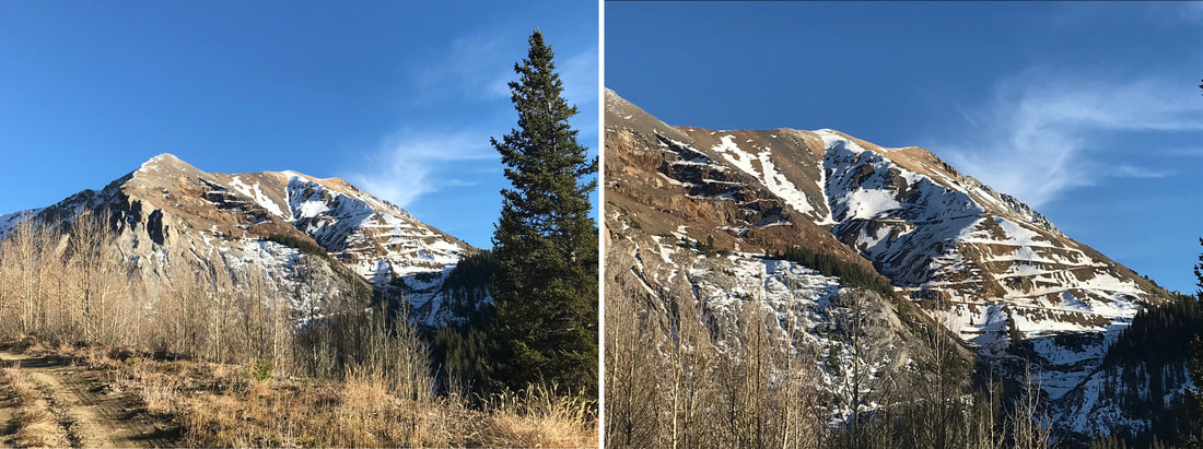 Mining scars from Cooper Fork Quarry and Pitkin Iron Mine near Taylor Peak Last week I attended a meeting of a “cooperative” group made up of federal, state, and local government, conservation organizations, and other advocacy groups that create dialogue around a variety of controversial land and water issues. Two of the topics which were briefly discussed at the meeting were covered in a previous blog post. Efforts continue to address Aspen’s water needs and transfer its existing water rights from Maroon Creek. The tension around this issue between the representative of the city of Aspen and a prominent local conservation organization was noteworthy. A new video advocating Wild and Scenic River designation for the Crystal River was also previewed. A 2013 settlement agreement eliminated conditional water rights for two potential dams in the Crystal River watershed. Fearing future water development projects and out of basin diversions, conservationists have been trying to gain local support for protection of the upper 39 miles of the main stem of the Crystal under the Wild and Scenic Rivers Act of 1968. Discussion at the meeting clarified that opposition stems from resentment of any federal control placed on local landowners. In the State of Colorado only 76 miles of the Poudre River is designated and protected as Wild and Scenic and there are few rivers like the Crystal that are not already dammed. You can find out more about efforts to protect the Crystal here. Water diversions remain the greatest threat to Roaring Fork watershed health, but since I have already reported on them pretty extensively, I thought it might be interesting to spend some time focusing on another feature and potential threat to the watershed: mining. Current and historical mining activities in the watershed are not nearly to the extent that has occured in other areas of the state, but the history of mining in the area has left a considerable mark on the landscape. Many of the hikes that I have taken have included passing relics of abandoned mines. Many of the views that I have admired have included mining scars that I usually choose to leave out of the camera’s frame. And many of the roads that I have travelled, which fragment the landscape, are the result of the area’s mining history. The Colorado Geological Survey website indicates that there are an estimated 23,000 abandoned mine lands (AML). Nearly 800 of them are in Pitkin County. Gravel is currently mined adjacent to stream areas, but most of the impacts from mining in the watershed are the result of the legacy of the late 1880s mining boom. Efforts have been made by Pitkin County and nonprofits to purchase mining claims in the area to eliminate the possibility of future developments. There are different kinds of mining activities. Placer mining (mining streambed) destabilizes streambanks, aggregate mining (crush, gravel) harms groundwater systems and lode mining (extract from tunnels) produces toxic mine drainage that harms riparian areas. From The Burden of Gilt: The legacy of environmental damage from abandoned mines, and what America should do about it, published by the Mineral Policy Center in 1993: “erosion, leaching, and acidification – all natural occurences – can trigger highly unnatural and undesirable phenomena when they interact with mine waste, tailings, and old workings.” The State of the Roaring Fork Watershed Report 2008 detailed some of the specific threats to the watershed. Disposal sites from metal and coal mining directly impact riparian areas with waste rock dumps, tailings, mill sites, and tailing ponds. Scars from past mining activity destabilize hillslopes, eliminate riparian vegetation, degrade riparian soils, and are a source of stream sediment. The 2012 Roaring Fork Watershed Plan identified Coal Creek, Ruby Mine, Thompson Creek, and Smuggler Mountain as sites requiring sustained reclamation. Smuggler Mountain was designated by the EPA as a Superfund site because of elevated lead and cadmium levels in soils. Cleanup and remediation activities were completed in 1996, but ongoing mitigation activities are required. Ruby Mine discharges mine drainage into Lincoln Creek. And high iron levels in Coal Creek are likely attributed to mining activities. In addition Castle Creek contains historic mining roads that crisscross the landscape provide motorized access into relatively pristine habitat, facilitate damage to fragile tundra plants and soils from vehicles illegally driving off-road and promote the spread of noxious weeds. 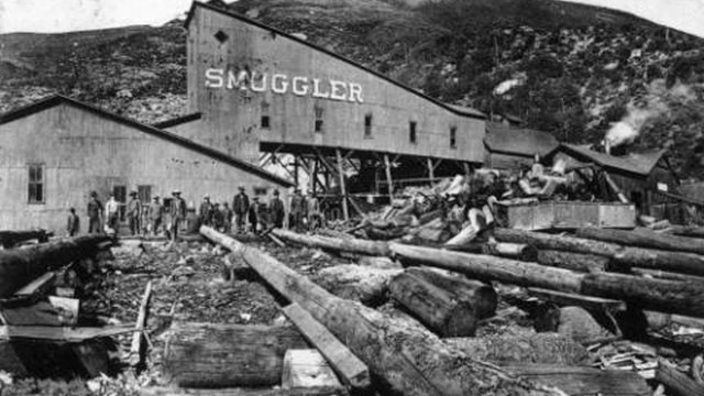 photo: http://www.9news.com/img/resize/content.9news.com/photo/2017/10/05/Smuggler_Mine_Aspen_Colo_1507228815866_11315933_ver1.0.jpg?preset=video-still In the 2012 Roaring Fork Watershed Plan, reclamation of mining sites was identified as a priority, but not in the most urgent category. The possibility of contamination on the scale of the gold king mine spill into the Animas River is unlikely in this watershed. Projects using biochar have been promising. Biochar is a substance made from burning biomass in an oxygen-limied environment, resulting in a stable form of carbon that has superior water-and nutrient-retention abilities, which is used to reduce metal toxicity and boost fertility of compromised soil. 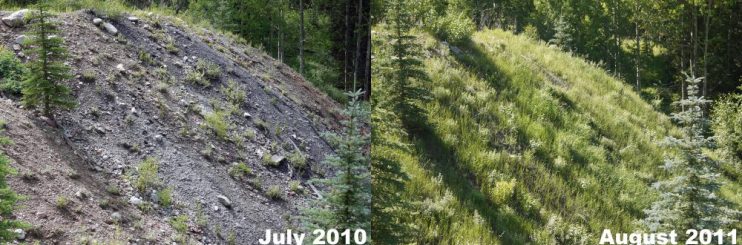 photo: https://www.aspennature.org/restore/forest-ecosystem-health/hope-mine-biochar-project This week's focus is trees. I tried to up my game to make my visuals a little more compelling. Looking at the different applications used by my fellow students was almost as interesting as the content in their blogs. Each application has very different strengths and weaknesses. I am not a fan of external links to blog content (I prefer the content to flow within the site and links to be reserved for external content) so I worked within the constraints of the slide show functionality of weebly, which is not one of its strengths. The slides were created in vector software and converting them to jpeg for import degraded the clarity , but I still think it looks pretty good. And now on to the slide show: 
Last week I hiked into the Raggeds Wilderness around Yule Pass. From Yule Pass (at the far left of this photograph) water drains to Yule Creek (to the right) and into the Crystal River (a sub-watershed of the Roaring Fork). On the other side of Yule Pass water drains into the Slate River then into the East River then into the Gunnison River and finally into the Colorado River. Snow is just beginning to accumulate on the high peaks with Fall storms and colder weather.
The Roaring Fork Conservancy (RFC) is the primary conservation organization for the Roaring Fork watershed. With both the Colorado State Water Plan and the Colorado Basin Implementation Plan calling for increased stream management planning, RFC was a partner in the publication of the Crystal River Management Plan in 2016. While the headwaters of the Crystal are relatively healthy, surface diversion and floodplain development have impaired its lower reaches. The plan provided alternatives for balancing the objectives of meeting existing water needs and addressing ecosystem impairments. It led to prioritization of short and long-term management actions. The full plan can be found here: http://www.roaringfork.org/media/1352/crmp_noappendix_bleeds.pdf Here is some basic information about the Roaring Fork Conservancy:
Another organization that is worth mentioning is the Colorado Water Trust, whose mission is to restore and protect instream flows using market-based and voluntary mechanisms. In 2016 they completed a ten year agreement with the City of Aspen to use its senior water rights to bolster flows to the Roaring Fork during dry years. You can read more about the Wheeler Ditch project here.
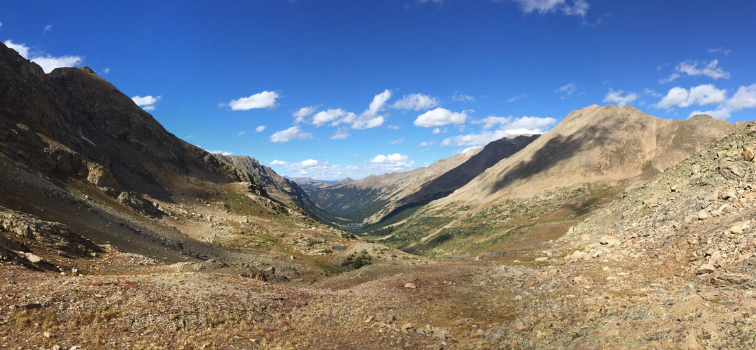 Fall is here. The weather has gotten rougher and storms are now dusting the peaks with snow. With a couple of stormless days predicted, I decided to leave the leaf peepers behind and head to the high country. My trip had me straddling the continental divide. The photo above is looking down from a pass along the divide into the headwaters of the Fryingpan River, which is one of the sub-watersheds of the Roaring Fork. From the divide water either flows east into the Arkansas River or west into the Colorado River. Except, of course, for man's interference -- either by ingenuity or folly depending on how you look at it. This would be a good time to examine how water rights and water diversions impact the Roaring Fork watershed. I have prepared a slideshow that outlines some of the more relevant information. If you would like a closer look at the diversion maps, the one from the office of the state engineer can be found here: http://roaringfork.bluetent.com/images/maps/trns_mtn.jpg and the others can be found on the Roaring Fork Conservancy Website: http://www.roaringfork.org/your-watershed/watershed-facts/transmountain-diversions/ The Roaring Fork Conservancy has this nice little summation on its website: "The Roaring Fork Watershed is located in central Colorado on the west side of the Continental Divide. The watershed includes the Sawatch, Collegiate and Elk Ranges and seven 14,000 foot peaks. Melting snow on the high peaks collects and joins one of three main rivers - Roaring Fork, Fryingpan, and Crystal - and drains to the Colorado River in Glenwood Springs which is at an elevation of 5,916 feet. Encompassing an area of 1,451 square miles [or 928,640 acres], the Roaring Fork Watershed is approximately the size of Rhode Island. As part of the larger Colorado River Basin, which supplies water to nearly 40 million people in the arid southwest, the Roaring Fork Watershed contributes about 856,000 acre feet or 279 billion gallons of water each year to the Colorado River." The higher elevations of the watershed are on White River National Forest, including protection within multiple designated wilderness areas. The Forest, including the portion within the watershed, is a heavily visited recreation destination including multiple ski areas and the Maroon Bells Scenic Area. The majority of the lower elevation river valley is private land, though portions are protected as Pitkin County Open Space for both conservation and recreation purposes. The majority of the watershed is in Pitkin County with the northwest corner in Garfield County, the northeast corner in Eagle County, and the southeast corner in Gunnison County. The watershed includes the resort towns of Aspen (population ~7,000) and Snowmass (~3,000) and the down valley communities of Basalt (~4,000), El Jebel (~4,000), Carbondale (~7,000), and Glenwood Springs (~10,000). The following maps show the extent of the watershed as well as the subwatersheds contained within the Roaring Fork. Both are courtesy of the Roaring Fork Conservancy. 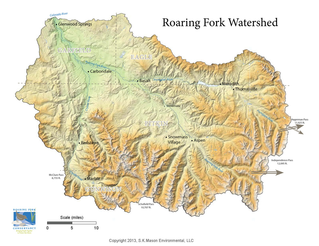 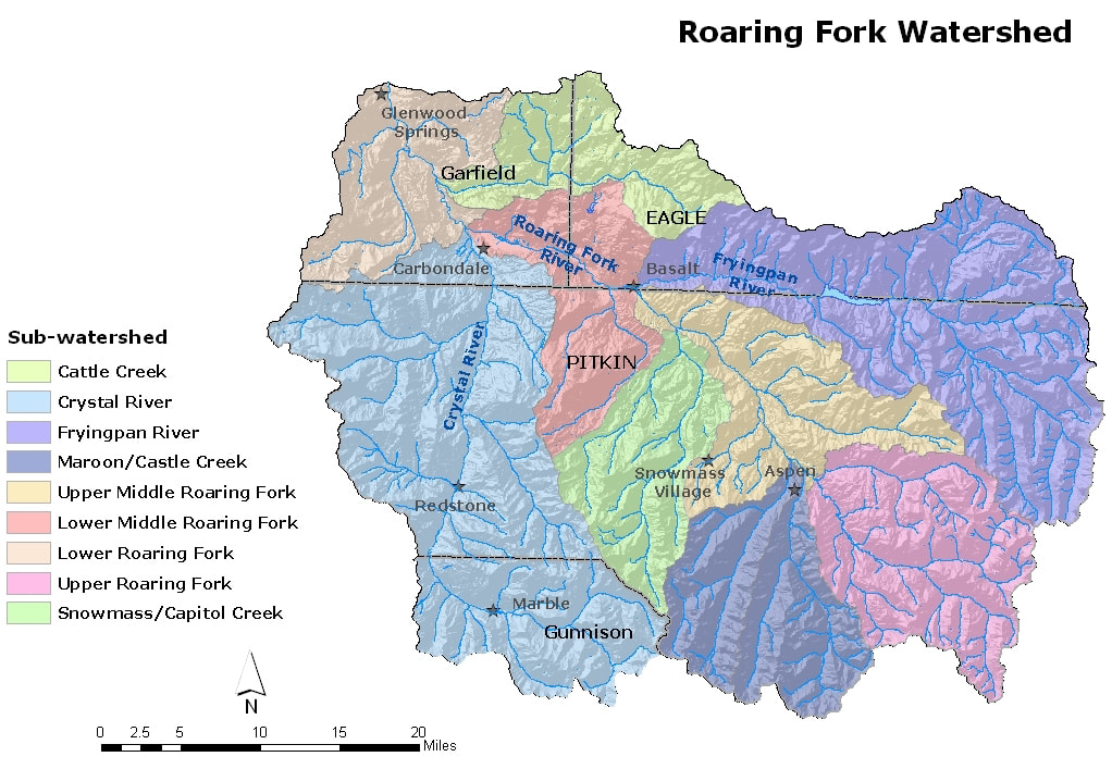 |
Archives
December 2017
Categories |
 RSS Feed
